North Dakota
in order of admission, the thirty-ninth state of the American Union. It lies on the Canadian border, between Minnesota and Montana, fairly midway between the two oceans. The state is rectangular in shape, save that the eastern border is formed by the Bois de Sioux and Red Rivers. Area, 70,795 square miles. Speaking in a general way, the surface is a vast level or rolling prairie. The Turtle Mountains on the Canadian border rise to a height of 2,500 feet. The southwest corner of the state contains a series of hills and scattered buttes, the Bad Lands. A region of clay and soft stone buttes lies near the western border. When a young man President Roosevelt tried his hand at ranching at Medora in this region.
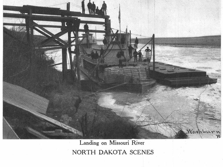
Topography. The Missouri enters the western border just above the mouth of the Yellowstone and flows southeastward through a broad valley bordered by high bluffs. It is a yellow flood with shifting sands, but is navigable for steamboats under skillful pilots. The Red River of the North, navigable for small boats, flows northward to Lake Winnipeg. It drains the former basin of a vast glacial inland sea known as Lake Agassiz. A loop of the Mouse River enters from Canada. Between the Red and the Missouri are the parallel valleys of the Sheyenne and the James. The former turns sharply eastward into the Red. The James continues southward for 600 miles to the Missouri. It is longer than the Elbe, the Rhone, or the Seine; but, except in time of flood or melting snow, it has the appearance of a prairie creek. It is said to be the longest non-navigable stream in the world. Its entire valley is a vast artesian basin. Flowing wells may be had anywhere. North of the headwaters of the Sheyenne lies Devil's Lake, the Minnewaukan of the Dakotas. It is a shallow, brackish body of water having no outlet. It is about twelve by fifty miles in extent.
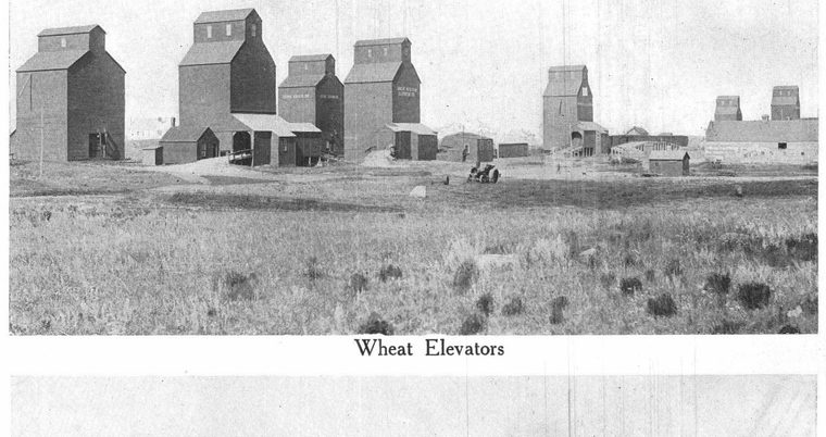
Agriculture. North Dakota is naturally an agricultural and stock-raising state. The Red River Valley is considered one of the most fertile wheat-growing sections of the world. The valleys of the Mouse, Sheyenne, and James bring the annual wheat crop up to 90,000,000 bushels. The leading grade, No. 1 Hard, is considered the best flour-producing wheat known. North Dakota leads the Union in the production of flax. Next to wheat and flax, in order of importance, come oats, barley, corn, and potatoes. A large amount of wild hay is baled and exported.
The amount of rainfall decreases from east to west. The Red River Valley expects twenty inches a year; the western border, half that amount. The one hundredth meridian is theoretically the limit of successful field crops, but there are semi-arid sections east of that line, and there are excellent agricultural lands west of it, especially at the big bend of the Missouri.
The western section is devoted largely to stock raising. Native grasses cured in the stalk afford the best of feed the year around. Dakota grass-fed cattle command the best of prices. The wool clip is rather above 3,000,000 pounds a year. Of late, creameries and cheese factories have sprung up in various parts of the state.
MINERALS. In coal area North Dakota ranks fourth in the Union. Lignite coal appears to underlie the entire western section. Its manufacture by pressure into briquettes has begun. It is hoped that in this form, it may prove satisfactory for the use of locomotives. It is believed that the vast amount of cheap fuel at hand may be utilized to pump the waters of the Missouri into irrigating ditches and convert a large area, now sparsely covered with grasses, into farming lands of unsurpassed fertility. The natural richness is in the soil, waiting only for moisture.
Aside from glacial boulders and sandstone in the west, the state is remarkably deficient in building stone. Brick clay is, however, abundant, and of excellent quality. Facing brick, firebrick, and tiling are already articles of export. A limestone suitable for Portland cement of high grade has been found in Cavalier County. This furnishes material for concrete work.
TRADE AND COMMERCE. The state is crossed from east to west by the Northern Pacific and the Great Northern railroads. The Sault, the Milwaukee, and the Northwestern systems reach extensive sections. The larger towns are situated at the points where the railroads cross rivers. Fargo, at the Northern Pacific crossing of the Red River, is said to distribute more gang plows, seeders, drags, binders, and threshers than any other town in the world. Grand Forks, seventy miles farther north, at the Great Northern crossing, is also a distributing center of importance. Other Northern Pacific towns are Valley City, at the crossing of the Sheyenne, and Jamestown on the James; while Bismarck, the capital, and Mandan, an old Indian encampment, are on opposite sides of the Missouri.
ANIMALS. North Dakota is the least forested state in the Union. About one per cent is covered with timber. Fringes of poplar, willow, cottonwood, and ash, plum, cherry, and birch, and occasional groves of oak and elm usually follow the streams and border the lakes. The characteristic animals of the prairie are ground squirrels, (incorrectly known as gophers), prairie chickens, jackrabbits, and coyotes. Deer are found in the Pembina region; grizzlies and brown bears in the southwest. Muskrats and minks, a few otters, and now and then coons, are taken by the trappers along the streams and around the lakes. Ducks and wildgeese glean the stubble fields in autumn.
HISTORICAL. As early as 1810, Lord Selkirk, supposing himself in the territory of the Hudson Bay Company, founded a settlement, afterward abandoned, at Pembina on the Red River. Devil's Lake was visited by Fremont in 1839; Mandan, by George Catlin in 1841. North Dakota was originally a part of the Territory of Minnesota. In 1861 the Territory of Dakota was organized, including at first Montana and parts of Idaho and Wyoming. In 1868 the territory was cut down to Dakota proper, and in 1889 it was divided and admitted to the Union as North Dakota and South Dakota. The state constitution prohibits the liquor traffic.
EDUCATION. From the first North Dakota has taken a progressive stand, especially in matters of education. The national grant of sections sixteen and thirty-six in each township for educational purposes has been wisely managed. By constitutional proviso none of this land may be sold for less than $10 per acre. The result is a large and increasing school fund, amounting in 1905 to $8,000,000. The income is used to support efficient common schools. An additional $3,000,000 has been set aside for the various institutions. The larger towns maintain efficient high schools. A vigorous state university with a school of mines is established at Grand Forks; an agricultural school at Fargo; normal schools at Valley City and Mayville; a school of forestry at Bottineau, and a scientific school at Wahpeton. The usual state charities are maintained on a liberal scale.
POPULATION. In 1885 a heavy Scandinavian emigration, attracted by fertile lands to be had for the asking, set in. Numerically the Swedish and Norwegian Lutherans are by all odds the strongest religious element. Next in order are the Roman Catholics, Presbyterians, Congregationalists, Baptists, and Episcopalians. The population in 1900 was 319,146. These figures should be increased to 437,070 for 1905. About 6,000 Dakota Indians are protected from the white man as best may be on reservations.
STATISTICS. The following statistics are the latest to be had from trustworthy sources:
| Land area, square miles | 70,195 |
| Population (1908) | 510,000 |
| Fargo (1906) | 13,097 |
| Grand Forks | 11,500 |
| Bismarck | 5,500 |
| Number counties | 45 |
| Salary of governor | $3,000 |
| U. S. representatives | 2 |
| Presidential electors | 4 |
| Bonded indebtedness | $692,000 |
| State revenue | $3,259,000 |
| Acres of improved land | 9,644,000 |
| Agricultural Products- | |
| Wheat, bushels | 90,762,000 |
| Corn, bushels | 6,045,000 |
| Oats, bushels | 49,600,000 |
| Barley, bushels | 20,727,000 |
| Rye, bushels | 478,000 |
| Flax, bushels | 14,229,000 |
| Potatoes, bushels | 4,400,000 |
| Hay, tons | 266,000 |
| Butter, pounds | 10,000,000 |
| Wool, pounds | 1,995,000 |
| Eggs, dozens | 8,000,000 |
| Manufacturing establishments | 507 |
| Capital invested (1905) | $5,703,000 |
| Operatives | 1,755 |
| Raw material | $7,095,000 |
| Output of manufactures | $10,217,000 |
| Output of flour and grist | $6,463,000 |
| Soft coal mined, tons | 347,000 |
| Clay products | $287,000 |
| Domestic Animals- | |
| Horses | 616,000 |
| Milk cows | 224,000 |
| Other cattle | 642,000 |
| Sheep | 627,000 |
| Swine | 233,000 |
| Fowls | 1,500,000 |
| Miles of railway | 4,000 |
| Teachers in public schools | 6,109 |
| Pupils enrolled | 124,000 |
| Percentage of male teachers | 21.2 |
| Average monthly salary of men teachers | $52.00 |
| Average monthly salary of women teachers | $45.00 |
| Average annual expenditure per pupil | $40.28 |
See Wheat; Lake Agassiz; Bad Lands; Missouri River; Bison